 TheLines of Peru
A Nazca trapezoid, looking like a runway, seems to invite the observationaircraft to land. (Photos at top and left on this page courtesyof Micheal J.Way. Copyright Micheal J. Way)
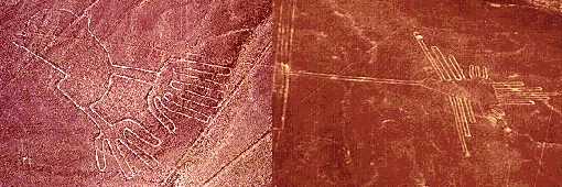
In the Peruvian desert, about 200 miles south of Lima, there liesa plainbetween the Inca and Nazca valleys. Across this plain, in an area measuring37 miles long and 1 mile wide, is an assortment of perfectly straight lines,many running parallel, others intersecting, forming a grand geometric form.In and around the lines there are also trapezoidal zones, strange symbols,and pictures of birds and beasts all etched on a giant scale that can onlybe appreciated from the sky.
The forms are so difficult to see from the ground that they werenot discovered until aircraft, being used to survey for water, spotted themin the early 1930s.The plain, crisscrossed, by these giant lines, many forming rectangles,has a striking resemblance to a modern airport. The Swiss writer,Erichvon Daniken, even suggested they had been built for the convenience ofancient visitors from space to land their ships. As tempting as it mightbe to subscribe to this theory, the desert floor at Nazca is soft earth, not tarmac, and would not support the landing wheelsof either an aircraft or a flying saucer.
 So what arethe lines for? The American explorer Paul Kosok, who madehisfirst visit to Nazca in the 1940s, suggested that the lines were astronomically significant and that the plain acted as a giant observatory.Gerald Hawkins, an American astronomer, tested this theory in 1968 by feedingthe position of a sample of lines into a computer and having a programcalculate how many lines coincided with an important astronomical event.Hawkins showed the number of lines that were astronomicallysignificant were only about the same number that would be the result ofpurechance. This makes it seem unlikely Nazca is an observatory.
Perhaps the best theory for the lines and symbols belongs to Tony Morrison,the English explorer. Morrison, by researching the old folk ways of thepeople of the Andes mountains, discovered a tradition of wayside shrines linked by straight pathways. The faithful would move fromshrine to shrine praying and meditating. Often the shrine was as simple asa small pile of stones. Morrison suggests that the lines at Nazca weresimilar in purpose and on a vast scale. The symbols may have served as specialenclosures for religious ceremonies.
How were they built? Straight lines can be made easily for great distanceswith simple tools. Two wooden stakes placed as a straight line would beused toguide the placement of a third stake along the line. One person sights alongthe first two stakes and instructs a second person in the placement of thenew stake. This can be repeated as many times as needed to make an almost perfectly straight line miles in length.The symbols were probably made by drawing the desired figure at somereasonable size, then using a grid system to divide it up. The symbolcould then be redrawn at full scale by recreating the grid on the groundand working on each individual square one at a time.
The lines at Nazca aren't the only landscape figures Peru boasts. Some850milessouth is the largest human figure in the world laid out upon the side ofSolitary Mountain. The Giant of Atacama stands 393 feet high and issurrounded by lines similar to those at Nazca.
Along the Pacific Coast, inthe foothills of the Andes Mountains, is etched a figure resembling a giantcandelabrum. Further south Sierra Pintada, which means "the painted mountain"in Spanish, is covered with vast pictures including spirals, circles, warriorsand a condor. Archaeologists speculate that these figures, clearly visiblefrom the ground, served as guide posts for Inca traders.
Some of the Nazca figures.

Copyright Lee Krystek 1997. All RightsReserved.