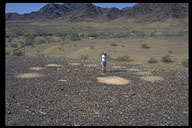
The Colorado Desert contains many mysteries, but none is more enigmatic than the Mule Canyon Geoglyphs. Located about 10 miles southwest of Blythe, they consist of clusters of circles cleared in the desert pavement, and arrayed in horseshoe-like patterns. Prior to World War II, an archaeologist passed through this region and made no note of these designs, although he recorded a dance circle and trail at this location. When combined with the fact that no other intaglio sites resemble the patterns seen here, many archaeologists have concluded that these must be recent creations. The likely candidate for this is General George Patton's troops, who conducted war games in this area during World War II, often leaving their tracks on the ground.
Other archaeologists have interviewed former members of Patton's troops, and looked at other known sites used during the war games. They have concluded that the Mule Canyon Geoglyphs bear no resemblance to known examples of Patton's campsites, and that the Mule Canyon images may be Native American in origin. If so, they may have been used in group ceremonies to commemorate mythic events, like other geoglyphs in the region.
How to get here
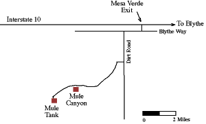
Four-wheel drive required. Mule Canyon is located about 5 miles southwest of the Mesa Verde exit off Interstate 10, 7 miles west of Blythe. Head west on the south frontage road (Blythe Way) along the highway. After about 1 mile turn left down a dirt road bordered by a power line. Take this for about 2 miles to another road trending southwest towards the Mule Mountains. Look for a fenced area on the northeast side of the mountains, about 1 mile west of a NW-SE trending power line.