Only some of the Pictures here are mine, but all the text is mine.
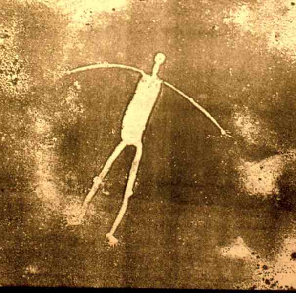
Over 200 huge figures are carved into the ground along the Colorada river from southern Nevada to to the Gulf of California, the first be noticed was the giant near Blythe, CA from the air in 1923. A pilot named George Palmer noticed the figure of a human with outstreched arms on a flight from Las Vegas to Blythe, on a second pass the other figures at the site were discovered.
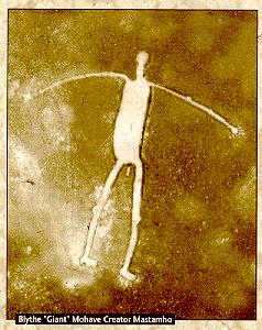
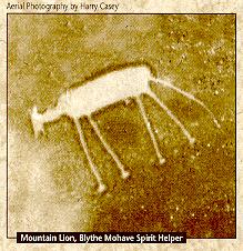
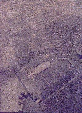
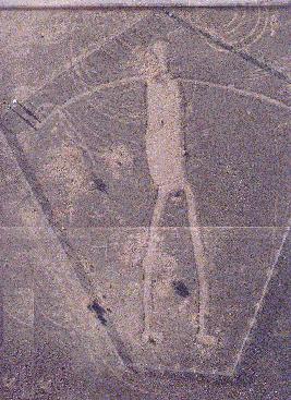
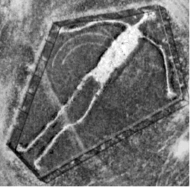
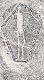
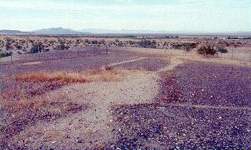
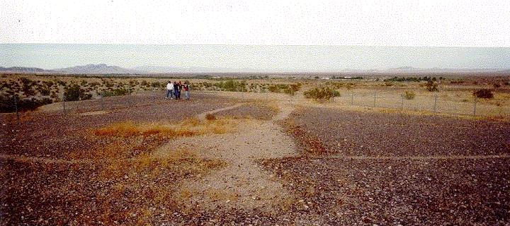
The Blythe Geoglyphs are made up of three locations. Included are a human figure at each and an animal figure at two of the locations. The largest human figure measures 171' from head to toe. Their age could be more than 2000 years, but they are at least 450 years old.
According to the Mohave and Quechan tribes of the Lower Colorado River, the human figures represent Mastamho, the creator of earth and all life. The animal figures represent Hatakulva, one of two mountain lions/persons who helped in the creation. In ancient timesm sacred ceromonial dances were held in the area to honour the creator of life.
BLYTHE INTAGLIOS
PROPER SITE NAME: Blythe Intaglios
DIRECTIONS TO SITE: About 15 miles north of Blythe, California, on California State Route 95
BRIEF DESCRIPTION OF SITE: Prehistoric earth figures or geoglyphs
FACILITIES PROVIDED: None provided
FEATURES: There are a total of six distinct figures in three locations, including a human figure at each location and an animal figure at two locations. The largest human figure measures 17 1 feet from head to toe. Their age could be more than 2,000 years, however they are at least 450 years old. According to Mohave and Quechan tribes of the lower Colorado River area, the human figures represent Mastamho, the Creator of Earth and all life. The animal figures represent Hatakulya, one of two mountain lions/persons who helped in the Creation. In ancient times, sacred ceremonial dances were held in the area to honor the Creator of life. These intaglios are best viewed from the air.
FEES/PERMITS REQUIRED: No fees or permits needed. Open to the public 24 hours per day, all year long.
LIMITATIONS: Please keep all vehicles on the designated roadway and help preserve these cultural resources for future generations to appreciate.
ACCESSIBILITY: Limited, easy hiking (less than 1/4 mile) to two of the site areas. The third site area requires 1/2 mile hike, part up a 10% grade. Paths are unimproved natural gravels.
My Visit to the Blythe Figures
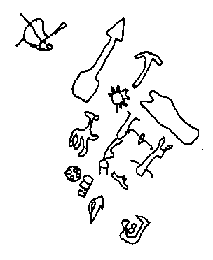
There are many other figures near this site, a mountain lion, a power station and a sprite.

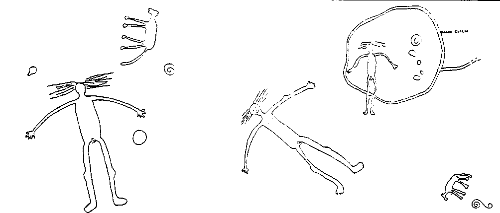
There are several figures in the Yuma region, Kumastamo (25m high and 6m wide), depicted differently than at Bouse and at his feet is an old world symbol known as Solomons Cross, there is is his evil brother Katar. Kukumat, the father god is also nearby.

Situated just south of Quartzite, AZ is a group of 14 geoglyphs. From Highway 95, take route 10 west and come off south from exit 17, onto Kuehn St, follow it east, then take Kofa Av, whic is a rightturn. This is a dirt road, which corsses an airstrip, continue past the mobile homes and take the right fork past these. The geoglyphs are fenced a little way from the fork.
There are many unusual drawings here, one of which is a large arrow which points exactly to the Bouse Fisherman about 10 miles away.
My Visit to the Quartzite Figures
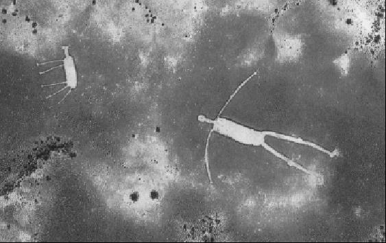
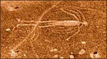
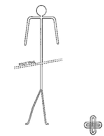
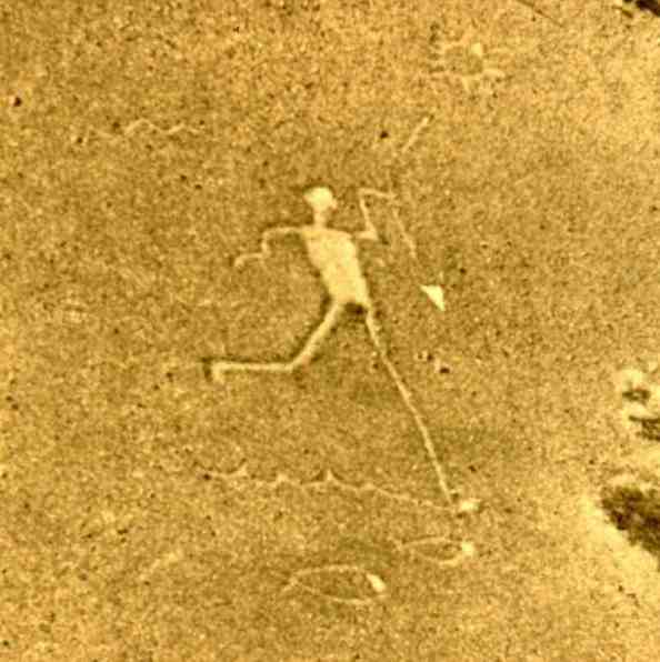
Situated north of Quartzite, AZ, is the Bouse Fisherman which is a different version of Kumastamho "The Creator".
This site does represent a person spearing fish, but recent ethnographic research revealed a second
and older meaning. The human figure is representing the great creator Kumastamo, while he creates
the mighty Colorado River to bring water to otherwise dry deserts of the region.
Legend states he made his way to the north, where he plunged his spear into the ground searching for water. On the first
try water did surface, but ran north away from the desert. After three more
tries Kumastamho was able to get the water to run south-southwest to the desert where it was needed. Then
he took the very powerful quartz point of his great spear, dragged it across the dry
earth, making a path for the water to follow. When he came to rocky areas, he
turned the spear on edge and wiggled it through the rock, creating what is now known as the
Colorado River.
It can be found 8 miles east of Highway 95, take 95 north out of Quartzite, take a right turn onto Plomosa Rd.
Follow Plomosa road east from the 95 until a gravel turn out can be seen on the left, just after a left bend.
Follow the path to the Fisherman, which is fenced.
My Visit to the Bouse Fisherman
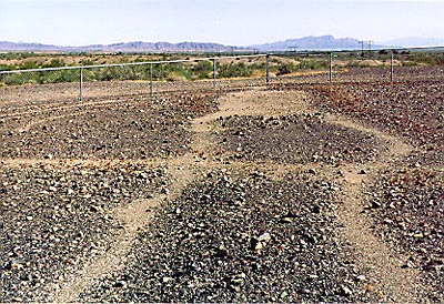
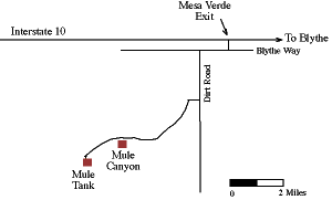
The Colorado Desert contains many mysteries, but none is more enigmatic than the Mule Canyon
Geoglyphs. Located about 10 miles southwest of Blythe, they consist of clusters of circles cleared in the desert pavement, and arrayed in
horseshoe-like patterns. Prior to World War II, an
archaeologist passed through this region and made
no note of these designs, although he recorded a
dance circle and trail at this location. When combined with the fact that no other
intaglio sites resemble the patterns seen here, many archaeologists have concluded
that these must be recent creations. The likely candidate for this is General George
Patton's troops, who conducted war games in this area during World War II, often
leaving their tracks on the ground.
Other archaeologists have interviewed former members of Patton's troops, and
looked at other known sites used during the war games. They have concluded that
the Mule Canyon Geoglyphs bear no resemblance to known examples of Patton's
campsites, and that the Mule Canyon images may be Native American in origin. If
so, they may have been used in group ceremonies to commemorate mythic events,
like other geoglyphs in the region.
Bouse Fisherman

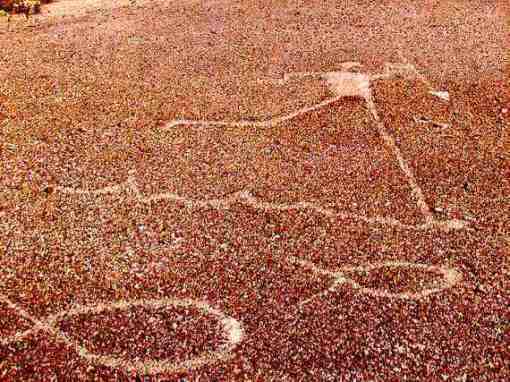
Mule Canyon Geoglyphs
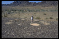
How to get there Four-wheel drive required. Mule Canyon is located about 5 miles southwest of the Mesa Verde exit off Interstate 10, 7 miles west of Blythe. Head west on the south frontage road (Blythe Way) along the highway. After about 1 mile turn left down a dirt road bordered by a power line. Take this for about 2 miles to another road trending southwest towards the Mule Mountains. Look for a fenced area on the northeast side of the mountains, about 1 mile west of a NW-SE trending power line.
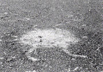
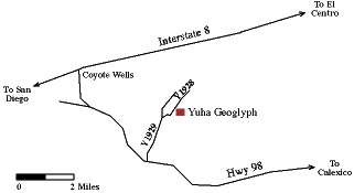
Located near the Mexican border in the Yuha Desert, east of Calexico, the Yuha Geoglyphs are a rare example of intaglios. Made by scraping away the desert pavement of darkened pebbles to reveal the lighter sand below, this site portrays an intricate pattern of geometric designs. Geoglyph sites like this were probably used in rituals commemorating myths, and for purification with ceremonial dances. Many geoglyphs are found in places said to be where the mythic events occurred. The Yuha Geoglyphs were nearly destroyed by vandals in 1975. Using aerial photos and maps, they were carefully reconstructed by Imperial Valley College and the BLM in 1981. They have been vandalized once again but an examination of the ground will reveal the faint but interesting ritual designs that are still preserved at this locale.
How to get there
The Yuha Geoglyphs are located north of Hwy 98 about 25 miles west of Calexico, on BLM Route Y1928 (dirt road) about two miles north of 98.
MISC.
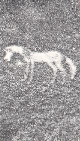
A more modern horse